


Advantage of Cochin Port
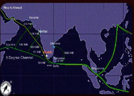
LOCATIONCochin, an all weather natural Harbour is located strategically close to the busiest international sea routes:
|
MODERATE CLIMATEThe Port is situated on the Willingdon Island which is an artificial Island tucked inside the Backwaters. The backwaters offer calm and placid channels for ships throughout the year, even during the Monsoon season.
|
OPERATIONAL EFFICIENCY24 Hour Pilotage
|
SERVICE QUALITYThe operational areas of the port is certified to ISO 9001:2015 standards.
|
CONNECTIVITYCochin port is connected to its hinterland enlarging to the state of Kerala ,South Tamilnadu and South Karnataka by National Highways NH 47(Kanyakumari-Salem), NH49 (Cochin-Madurai) and NH17(Cochin-Mumbai) .Indian Railway Network provides seamless connectivity to South and Central India.The National Waterway NW3 provides connectivity to the South Kerala.The port has an international airport in its proximity. The network of railways roads, waterways and airways has created good accessibility to the port.
|
DEVELOPMENT PATHCochin Port is implementing ERP for enhancing efficiency.
|
PROXIMITY TO THE MARITIME HIGHWAY
|
Last updated :: 03/06/2020, -12:02
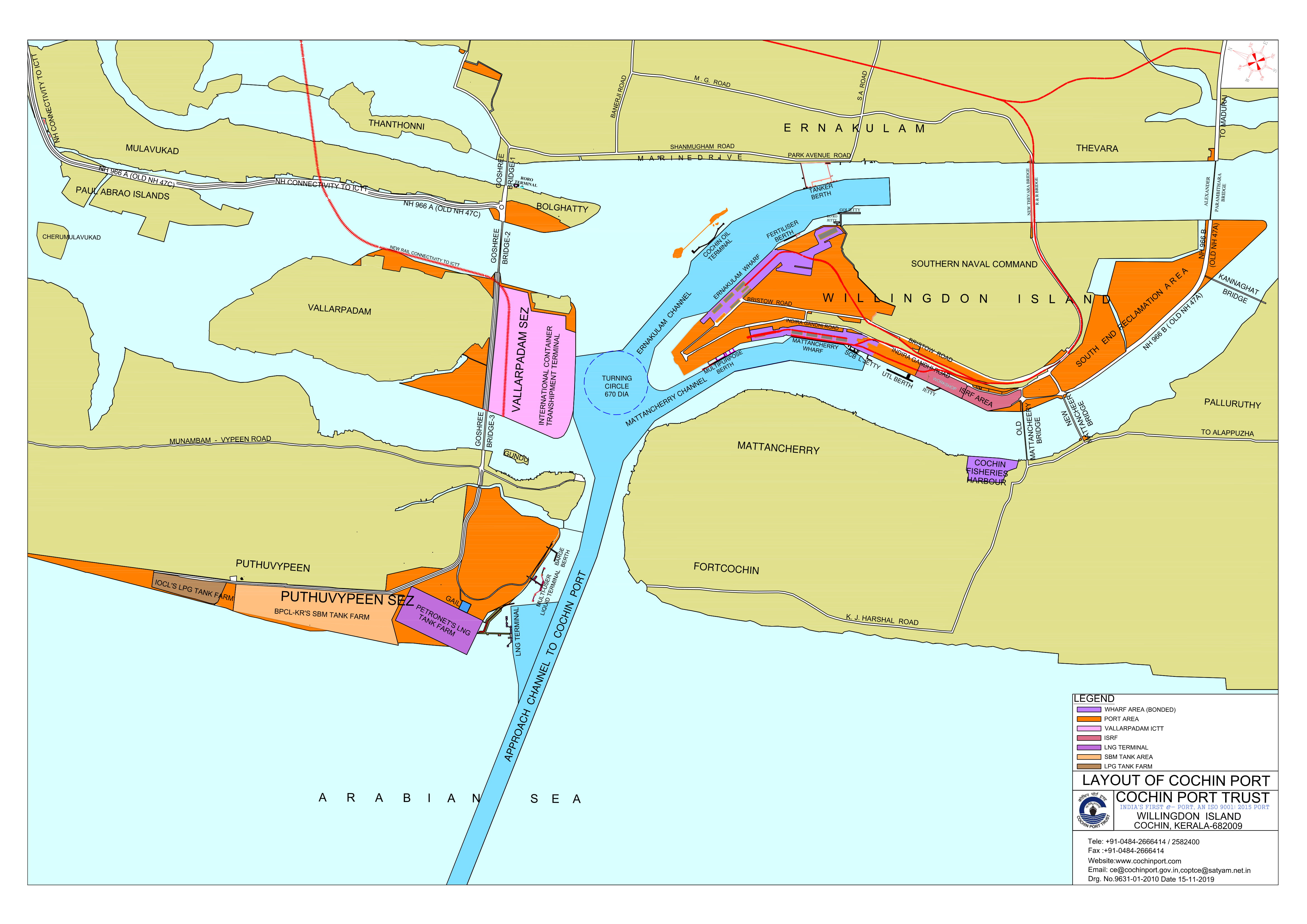
Port layout
Last updated :: 20/03/2020, -15:28
Climate & Tidal Info
CLIMATE & TIDAL INFORMATION
CLIMATE AND METEOROLOGY
Temperature and Humidity
Temperature at Cochin varies from about 22 to 31 degrees C. There are not much distinct seasonal variations in the temperature, which is more or less uniform throughout the year. However, highest temperatures tend to occur in the months of March to May. The humidity is high all through the year. It ranges from approximately 75% in the morning during winter months to approximately 90 % in the monsoon period.
Winds and Cyclones
The wind speed and wind direction is determined by the season and by the daily temperature differences between land and sea. The predominant wind direction during the monsoon period ie, from June to September, is west to south-west and the effect of land breeze is not dominant during this period. During the non-monsoon periods, the predominant wind direction is from north-east during the morning and west during the evening, which shows influence of land breeze. The maximum wind speed observed was of the order of 112 KMPH from WSW direction. Cochin lies beyond the cyclone belt and therefore the risk of cyclone is negligible.
Rainfall
The maximum rainfall usually occurs during the monsoon period ie, from June to September. The annual rainfall in the region varies between 2500 to 3500 mm.
OCEANOGRAPHIC DATA
Tides
Cochin experiences semi diurnal tides. The tidal levels as per Naval Hydrographic Chart No.2004 are as follows.
| MHHWL | +1.20 m |
| MLHWL | + 0.80 m |
| MSL | + 0.60 m |
| MHLWL | + 0.60 m |
| MLLWL | + 0.30 m |
The above levels are with respect to Port's Chart Datum, which is approximately the level of Lowest Astronomical tide.
Current
The currents along the coast of Cochin consists of tide, wave and wind induced components. As per observations the maximum current velocities at the Cochin Gut during the non-monsoon periods is of the order of 3 knots, which could increase to as high as 5.5 knots during the monsoon periods. Inside the harbour the current velocities are low, of the order of 0.5 knots only, with directions varying at different locations.
Waves
The wave climate is governed by the South West monsoon when wave action can be strong with prevailing wave direction from north-west to south-west. Deep water (15m) wave observation in the past indicate the significant wave heights of 4m, 2m and 1m at the water depths of 10m, 5m and 2m respectively, the predominant wave direction being west. Wave action inside the harbour is insignificant because of narrow entrance between Cochin Gut and Fort Cochin and the configuration of the land. Generally calm conditions prevail through out the year except during the times of extreme wind action.
Bathymetry
The sea bed slopes gently in the offshore region and is about 1 in 500-600. The coast experiences the littoral drift as anywhere else but there is a phenomenon of formation of the mud banks. The mud banks are not stationary and have a tendency to move in the coastal region.
TIDAL STREAMS
The maximum rate of the ebb stream at springs throughout the year is from 2 to 3 knots and at Neaps from 1/2 to 11/2 knots.
| Ebb Stream Springs | 2 - 3 knots |
| Ebb Stream Neaps | 1/2 to 11/2knots |
| Flood Stream Springs | 11/2 - 2 knots |
| Flood Stream Neaps | 1/2 to 11/2 knots |
Both streams run for considerable time after the predicted times of High and low water, for about 2 hours on the flood and 2 - 3 hours on the ebb. After heavy inland rains the ebb stream may run continuously for many days, while the flood stream enters the harbour under the surface ebb.
SALINITY
Within the harbour the salinity varies from 1005 to 1020 depending on the season and state of tide.
Last updated :: 20/03/2020, -15:31